South to Alaska
Scenic delights on the road less traveled
After two weeks touring Alaska I was headed back south on the Alaska-Canadian Highway, also known as the Alaska Highway or simply the ALCAN. I never like to ride the same highway twice if I can help it and I did have another choice for the ride home. I had stopped at Teslin in the Yukon Territory of Canada for gas and a cup of coffee on my way to the Cassiar Highway. Two other riders pulled in for gas at the same time. They were headed north. After some conversation they asked where I was headed and I told them south to Alaska. They both had a puzzled look on their face and asked, “Don’t you mean north?” My response was, “No, I mean south.” As they walked away I heard one say, “Joe, I hope he will be OK. He doesn’t even know which way Alaska is.” I just had to laugh.
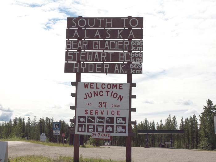
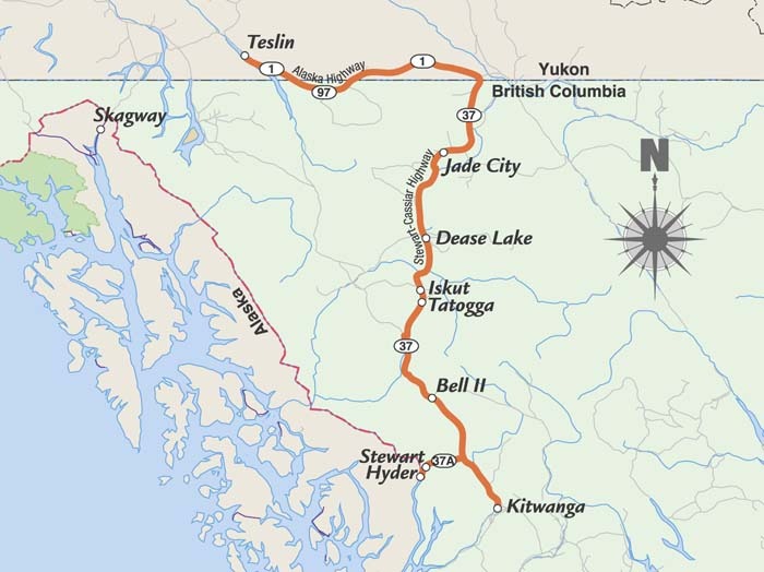
There are two routes to Alaska by road. Most think of the ALCAN as the only route, but there is another. British Columbia Highway 37 will get travelers to Alaska going north or south. Highway 37 is better known as the Cassiar Highway. The Cassiar Highway extends from the ALCAN just north of Watson Lake to the junction of Highway 16 at Kitwanga. On this day I was headed south to Hyder, the southernmost part of Alaska that can be reached by road and the easternmost town in the state.
The Cassiar is 450 miles in length and traverses some of the most remote and beautiful country in the world. The history of this region dates back to 1833 when the Hudson’s Bay Company established a trading post at what is now Dease Lake in British Columbia. In 1865 the Collins Overland Telegraph Company started to build a telegraph line north in an attempt to link North America with Europe via the Bering Strait. This all came to a halt when a cable was laid across the Atlantic.
The mining history in the region dates back to 1861 when gold was discovered. In 1950 asbestos was discovered in the Cassiar region and a mine and town site were established. The asbestos was trucked north to the ALCAN on to Skagway where it was placed on ships. The town is now abandoned and the mine closed. The Canadian Government continued to push a road through from the south, which was completed in 1972. Much of the road was gravel then.
I stopped at the junction of the Cassiar (sometimes called the Stewart-Cassiar Highway) and gassed up since I knew the next gas would be at Dease Lake 147 miles down the road. Never pass up a gas stop on the Cassiar. They are few and far between and you never know which ones will be open on any given day.
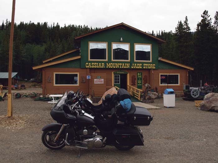
Over 98 percent of the highway is paved now with either seal coat or pavement. Riding south the first thing you will notice is there were no side or centerline markings, and the seal coat road has no berm. The country becomes very remote with great views of the mountains, rivers and lakes. The road winds through the wilderness and pretty much follows the terrain, which is kind of like a roller coaster. Headed south, the road passes through Boya Lake Provincial Park and on to Good Hope Lake. After passing Good Hope Lake I encountered about a mile of hard-packed gravel and a black bear standing alongside of the road watching as I passed. My next stop was Jade City, population 12. Jade City claims to be the jade capital of the world. The beautiful green gemstone is mined here and made into about anything you could want. The gift shop has an extensive collection of items for the traveler to purchase.
I finally rolled in to Dease Lake at 5:00 p.m. and had dinner next door to the Northway Motor Inn where I spent the night. There is not much in Dease Lake. There are two motels and one restaurant. The local grocery store—the only one within 150 miles in either direction—serves as the only gas station in town.
The next day I headed south again. About 30 miles down the road after entering Spatsizi Wilderness Park I encountered gravel again just as I started to descend into the Stikine River valley. At the bottom I crossed the Stikine River Bridge to find what little traffic there was stopped for construction. After about 30 minutes the pilot car showed up to lead us through the construction. Water had been put on the gravel to hold down the dust, but this made the road very slippery and caused some white-knuckled riding on some of the curves. The pilot car always seemed to slow down when I needed more speed to keep the bike upright in the loose gravel. Any time there is a pilot car riders are to pull to the front of the line and hopefully set the pace.
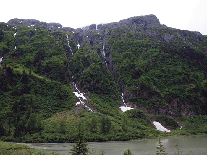
After about three miles the construction zone ended and I passed through Iskut, a small village that had a gas station that was closed. Just a few miles down the road I pull into Tatogga. After gassing up at Tatogga the road improved to pavement with side and centerline markings. From here on the Cassiar is as good as any two-lane in the lower 48. As I continued along this road, I encountered a number of one-lane wooden bridges, requiring me to be alert for oncoming traffic. And if it is raining these bridges can be very slippery. After gassing up one more time at Bell II I made the turn off at Meziadin Junction on Route 37A and headed west to Stewart, British Columbia, and then just a few miles west and over the border to Hyder, Alaska. The 30-plus miles between Meziadin Junction and that part of the Canadian/Alaskan border offered some of the most beautiful scenery of the ride.
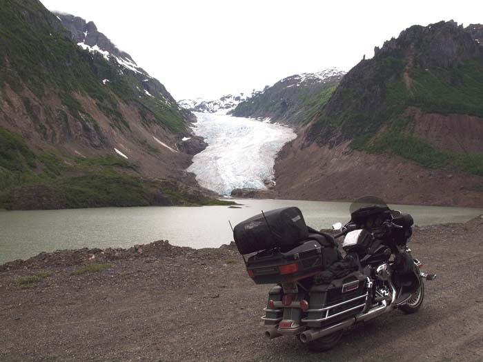
About a mile after turning onto Route 37A I saw a young grizzly standing next to the road, so I just had to stop and get a picture. I kept the bike running and kept my distance as the bear ran off. This road is a great place to spot both black and grizzly bears. As I continued on towards Bear River Pass the view was spectacular. On both sides of the road were glacier-capped mountains and one waterfall after another. Just a few miles outside Stewart is Bear Glacier. The glacier extends almost to the highway where there is a pull-off so you can get a close look. After stopping at Bear Glacier I continued on to Stewart where I planned to spend the night. After checking in at the King Edward I just had to ride the two miles to Hyder, often called the “Friendliest Ghost Town in Alaska.” Hyder sits at the end of the Portland Canal, a 70-mile-long fjord, which is the longest in the world.
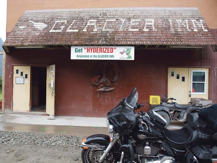
Two things I noticed as I approached Hyder are that there are no customs to clear crossing the border, and this is where the pavement ends. Hyder’s heyday was in the first half of the 20th century, but there isn’t much there anymore. The town does offer gift shops, a motel and RV park, post office, health clinic and the Glacier Inn. Now if you want to get “Hyderized” the Glacier Inn is the place to do it. The Everclear grain alcohol served is 150 proof. I passed on getting Hyderized and had a cold beer and wished the walls could talk. When Hyder was a booming mining town I’m sure it got a little crazy at the Glacier Inn. Eventually the mines closed and Hyder became pretty much what you see today—almost a ghost town.
About three miles up the gravel road from Hyder is the Fish Creek Observation Site. In July and August the salmon move upstream to spawn, and from the viewing platforms you can watch both black bears and grizzlies catching salmon. As luck would have it I was too early to see the bears. Riders can also continue on a number of miles to Salmon Glacier, the largest glacier in Alaska. The locals said the road was rough and rutted in spots so I decided not to make the ride up to the glacier.
I left the Glacier Inn, cleared customs back into Canada and rode the two miles to Stewart where I checked into the King Edward for the night. If you stay at the King Edward, I would recommend you eat at their restaurant. The prime rib and coconut cream pie was the best I have ever eaten. And if you are looking for king crab you will love the King Edward.
The next morning I rode back through Bear River Pass toward Meziadin Junction where I continued south on the Cassiar to the turnoff to Kitwancool. Kitwancool is famous for its native totem poles, some of which date back as far as 1850. On occasion informative tours are offered, but there was no one available on the day I was there. After spending time walking among this historical native art I continued on to Kitwanga and turned east on TransCanada Highway 16. As I rode towards Prince George all I could think of was what a great ride the Cassiar Highway is and how glad I was that I chose the other Alaska route to return home on. If a motorcyclist does not have the time to ride the ALCAN to Alaska, Hyder may be in reached in a lot less time and the area offers much of the scenery and wildlife you would see further north.


I came back from Alaska and down the Cassiar Highway in an old motor home in early July of 2005. Only two or three short stretches were not paved; but they were well graded. And I can think of no better trip for viewing scenery and wildlife. We spent a couple nights at Stewart and visited Hyder — but we were too early for the salmon run and bear watching.
So I returned to Hyder with my brother in early August of 2012. We spent a full week there at Camp Run Amok in a little trailer. We went to the Fish Creek observation platform every day to take photos of the bears and eagles feeding on the salmon. On one day we even got photos of a mother wolf and her adolescent pup visiting the creek. And two of us plan a return trip to the Cassiar Hwy. and Hyder again next spring (2019).
But first we’ll go through Banff and Jasper Parks, up the Hwy. 40 Bighorn Route to Dawson Creek, then up the Alaska Hwy. to Watson Lake before looping back the Cassiar.
My fifth book, titled “MORE Stories from The Gold Throne,” tells the of our 2012 Hyder trip, with numerous photos. I’m and old fart retired journalist and all my books are available on Amazon. They are non-fiction collections of short essays, including newspaper timeless columns and editorials, travel stories and memoirs. You also can see some of my more recent work by doing a search on my name through either Google or Yahoo.