An offering from the ancients
The high road of the mountain gods
Taos, N.M.—On my way back to Houston from South Dakota last fall, I decided to take advantage of an area of New Mexico that offers some of the finest riding opportunities in the Southwest, the Enchanted Circle. Standing 13,161 feet, Wheeler Peak is the highest point in New Mexico and serves as the hub for the Enchanted Circle Scenic Byway, a circuitous 80-mile mountain passage that encompasses five main towns—Taos, Questa, Red River, Eagle Nest and Angel Fire—and several ski resorts along with the Carson National Forest. It’s a short, high-attitude blast.
Taos makes a good base camp for exploration of the area and is the largest town of the five on this loop. But then the term “large” is somewhat a misnomer when you consider that Taos’ population is just slightly over 5,000. Taos celebrated its 400th birthday in 1998. It was 1598 when Don Juan de Onate left Mexico City with a caravan of 400 soldiers, 100 families and 7,000 head of livestock to colonize New Mexico. They were headed to the Taos Pueblo, which had first been discovered 58 years earlier by Spanish explorers who believed they had found one of the legendary golden cities of Cibola. In reality, they had stumbled across the Tiwa Indians, who had settled the Taos Valley 1,000 years before the Spanish arrived. Located at a junction of several crossroads, Taos soon became a major trading center, attracting the likes of mountain men Kit Carson and Ceran St. Vrain. It became an artist’s haven in 1914 when the Taos Society of Artists was formed. The resulting notoriety quickly lured noted artists Georgia O’Keeffe and Ansel Adams. Today the town is packed with museums and art galleries. (One gallery for every 86 residents at last count).
Although it bears little resemblance to the stockade it once was when it provided safety during Indian and bandit attacks, the Taos Plaza is still a major historic site and entertains thousands of visitors each year. Two of the most noted sites on the square are the Hotel La Fonda and the Old Taos County Courthouse. The La Fonda’s roots go back to an inn constructed at the same location in 1820. The Old Taos County Courthouse is now a “Mercado” and contains various gift shops. But upstairs, the old jail where Wyatt (Peter Fonda) and Billy (Dennis Hopper) first encountered George (Jack Nicholson) in Easy Rider still exists.
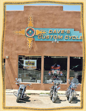
Old Taos is a baffling mixture of tangled intersections and confusing one-way streets. The traffic flow runs from terrible to mas terriblé, with drivers inventing their own rules. Luckily accommodations can usually be found near the Plaza, which places most of the decent sights, eateries and music venues within walking distance. (And Taos has a very vibrant night-life.) When I rolled into town, I headed straight for Dave’s Custom Cycles to catch up on the latest two-wheeled news. Getting the lowdown from locals on their favorite dining establishments is always a good precautionary measure. Dave is located on the main drag, Paseo Del Pueblo Sur (a.k.a. State Highway 68—New Mexico is famous for dressing up their road names), and has been in this spacious new shop for seven years. Dave’s list of available services covers a wide gamut (most everything except paint) and even includes an in-house dyno unit and 24-hour emergency road service (damn good thing to know in this country). Dave said business had been good and that the town’s police were just as tolerant as they were a few years earlier when I lived there. His only bitch was that the local newspaper had recently launched a campaign to establish a man-datory helmet law throughout the county. He didn’t seem too worried about that coming to fruition but it was something the area’s riders were keeping a watchful eye on. When I asked his recommendations for grub, he pointed me right up the street to the El Taoseno Restaurant & Lounge— an excellent establishment, full of local “color” where a plate of tasty tacos and several icy Mexican brews would run less than a fistful of dollars. There are fancier places in town to chow, but exercise some caution. Some carry “fancy” prices, while others are apparent holdovers from the hippie days of the ’60s and ’70s, with vegan and organic eateries in abundance. So unless you relish sprout burgers, take a close look at the place before entering.
Chance lodging can be just as varied as the dining possibilities. On this stay I ended up at the Hacienda Inn for a mere $65, which isn’t bad for a touristy town. But then I discovered that there was no AC (I didn’t really need it at night although it did get a little stuffy in the afternoon). Later, while attempting to secure some ice for a nightcap, I discovered the office had closed at 6 p.m. and no one would be back until the following morning. And I was the only occupant registered there that night. Kinda spooky. But on a positive note, after I un-loaded the bike, a cute chick did bring me a stack of towels to clean my bike. In times past, for an additional 20 bucks I’ve stayed at the Best Western on the north side of town. They served a free breakfast buffet and presented traditional native dancing around a fire ring each night. So once again, do some investigating.
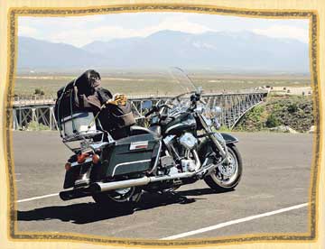
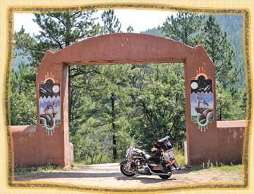
Also on the northern outskirts is the Taos Pueblo, home to approximately 150 full-time natives with more than an additional 1,700 living on the surrounding Taos Pueblo lands. The Pueblo welcomes tourists and offers several ceremonials each year including a powwow, corn dances and pole climbing celebrations. There is an admission charge of $10 per person along with a $5 per camera fee. And right up the road, the chair lifts at Taos Ski Valley offer an unparalleled view of the mountain vistas from late June to late September when all that white, fluffy stuff starts to get in the way. A nice side trip diversion can be found just northwest of town on US 64 where the rolling plains take a nosedive and the Rio Grande River has cut a trench in the earth. This is the Rio Grande Gorge Bridge. Standing at 650 feet above the river, it is one of the highest in the US and was the setting for a segment of the movie Natural Born Killers. Access to the midspan section is allowed on foot—just hang on, it shakes mightily whenever big trucks roll across. Built in the mid-’60s, it was originally called the “Bridge to Nowhere” because funding at the time didn’t exist to extend the road on the other side. But those times have changed and US
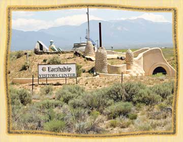
64 West continues on now to the Earthship Biotecture Center just a few miles down the road. This is an eco-sensitive compound dedicated to the use of recycled materials to build passive solar homes that resemble something from the mind of Dr. Seuss… on peyote.
If you have a hankering for an extended side adventure and something a little more traditional than “Who-ville,” continue another 60 miles on US 64 to the Cumbres and Toltec Scenic Railroad in Chama. Built 127 years ago, this railroad is owned jointly by Colorado and New Mexico and makes its 64-mile smoky trek between the two states seven days a week between the end of May and the middle of October. Highlights of the train ride include a couple of tunnels, two 100-foot trestles and Toltec Gorge with a view of the stream bed 600 feet below.
Back in towards town and on the actual loop of the Enchanted Circle and headed north to Questa on State 522, the rolling hills give way to some enjoyable inclines and descents, presenting some impressive vistas to the rider. But be cautious of sudden speed reductions while going through some of the smaller villages, as the New Mexico Highway Patrol favors these haunts to capture speeders. The numerous roadside memorial crosses that pepper this section of road may be an indication of the heightened surveillance of the area. The town of Questa is the second largest “city” on the Circle, with 2,000 inhabitants. Maybe due to its history of being raided by nomadic Utes and Apaches, it’s one of the most biker-friendly towns in the area. In Questa, take a right at the traffic signal and head east on Highway 38. This part of the loop will take you through Carson National Forest, which offers plenty of camping opportunities along the Red River. It’s only a 35-mile ride to the town of Red River but it’s quite a ride, a twisty road that traces the river and snakes its way around Wheeler Peak. With the mountainside to your left and nothing separating you from a long drop to the river on your right, exercise care at all times.
Red River was the hunting grounds of nomadic Apaches until gold fever struck and thousands of miners drove them out in the late 19th century. Red River is now a noted ski resort and tourist destination. Although there are many condos available, my favorite place to stay is the Pioneer Lodge, where you can fish in the establishment’s pond and cook your catch on your own back door grill. Both the Bull O’ the Woods and the Mother Lode are legendary biker hangouts, supplying great entertainment and a relaxed atmosphere.
Between Red River and Eagle Nest is Bobcat Pass, a 9,820-foot cut over the Sangre De Cristo Range where I have encountered both sleet and snow in June. The road between Red River and Eagle Nest is dotted with expansive horse ranches and log homes that are embarrassingly large. (Guess it takes a lot of land to feed those animals this high up.) Eagle Nest Lake State Park was established in 2004 and features great fishing to compliment its stunning scenic value. In Eagle Nest you pick up Highway 64 again. It will eventually lead back to Taos. But first you pass through the town of Angel Fire.
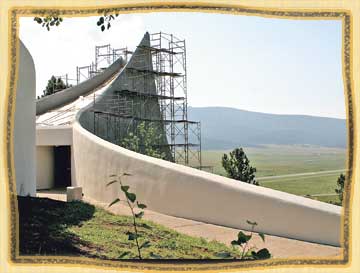
Several legends are bandied about concerning the origins of the town’s name. My favorite is that Kit Carson tagged it with that moniker after viewing the early morning sun’s rays illuminating the frozen dew. In 1971, Dr. Victor Westphall erected the Vietnam Veterans Peace and Brother-hood Chapel on the edge of town to honor his son, who died in the conflict. This graceful and simple curving wall overlooking Angel Fire was refurbished and renamed the Vietnam Veterans National Memorial and recognized by President Reagan in the late ’80s. It was once again undergoing new construction on the chapel when I rode through, along with some massive landscaping. It entertains a huge gathering of bikers each Memorial Day.
From Angel Fire west to Taos on Highway 64 is a short 20 miles but it’s as loaded with fine bike riding as any other section of the Circle. And it’s all Enchanted. Eastern routes to escape back to the flat Texas panhandle include Old West Cimarron and Springer. My favorite road headed south is 434. It originates in Angel Fire and goes past Coyote Creek State Park. This is a true backwoods passage that is at times one lane, follows an ancient trapping stream and includes 100-year-old cabins fallen into disrepair. It ends in Mora, home to some of the largest alpaca herds in the Southwest. (Don’t be surprised to see 100 alpacas storming the fence line if you slow down.)
Most of the roads around the Enchanted Circle are in decent shape for any bike, except for a few sections suffering damage by winter freezes. Beware of both domesticated and wild animals (some areas are free range) and keep an eye on your gas level since a lot of businesses close early. And due to the general attitude of the region, a lot of them open late also. Here, no one is in a hurry. And where mañana (tomorrow) is the status quo, why should you be the only one in a rush? Slow down and enjoy the ride. And then, mañana, get up and ride it counterclockwise for a completely different perspective.