Riding the tide
Cruising through a land of extremes
Like something out of a Stephen King novel, the fog–a cold, bone-chilling density–rides the tidal bore as it rushes across the vast plain. Advancing faster than a person can run is a volume of seawater equaling that of all fresh water rivers in the world. In six hours this land will be 40 feet beneath the sea. It’s the flood epic as described by the ancient Sumerians and retold in the Bible, and it happens every 12 hours and 26 minutes.
New Brunswick, Canada—The deep orange trench of the Chocolate River is to my left and Moncton, New Brunswick’s largest city, lies behind me as I head south on Route 114. The big Harley trike seems to roll down the highway of its own volition, which is a good thing. In the gray light that lies between dawn and sunrise I’m still half asleep while racing against the tide.
The Bay of Fundy is the most extreme tidal environment on the planet. Twice a day 23.5 quadrillion gallons of seawater rush into this cul-de-sac, inundating mudflats the size of Rhode Island 40 feet beneath the waves. And twice a day a hundred billion cubic meters of water disappear to expose what is known as Hopewell Rocks.
Recognized as one of the great natural wonders of the world, this site attracts millions of visitors a year, but I’ve arrived on a Sunday before park service employees have opened the gates and begun their daily routines. I’m alone except for a crying gull and a stationary heron so I watch my step. On the bottom of the ocean floor with the tide about to turn this is not the time, nor the place, to twist an ankle on seaweed-covered rocks. Printed photos don’t do them justice. Academics called them sea stacks, while the trees that grow on the tops of these towering columns of red sandstone have caused them to be colloquially known as “flower pots.” Sculpted by tidal waves, they form a garden of awesome beauty. Undercut and unstable, they eventually succumb and fall, merely token sentinels against the relentless erosion of time.
The Street Glide Trike rattles as its wide tires throw up loose asphalt. Applying Cold Patch to this battered highway is like putting lipstick on a pig, but County Road 915 is part of the scenic Fundy Coastal Drive. The route is clearly marked by blue and white signs with the icon of a lighthouse and I easily find the narrow winding access road that leads to Cape Enrage.
Named by Acadians for the wave action over a treacherous reef that extends into Chignecto Bay, Cape Enrage is a headland of towering cliffs on Marsh Barn Island. This lighthouse was saved from demolition in 1993 by a group of high-school students. The nonprofit Cape Enrage Interpretive Centre has since restored the property, including opening an excellent restaurant in the keeper’s cottage and having students offer courses in rappelling and kayaking. Declining an invitation to rappel down the sheer cliff to the water’s edge, I spend time watching several porpoises that are feeding close to shore. The views from the lighthouse are, of course, expansive.
Back on Route 114 and a mere 11 miles from Cape Enrage, I enter the Fundy National Park and make my way to the Park Services office. The park contains 25 waterfalls, upland forest, bogs, coastal access and three different camping areas, but I simply explore a few miles of dirt roads. What I certainly didn’t expect is a nine-hole golf course and a heated saltwater pool. Many camping sites are on a first-come basis, but a few can be reserved (877.737.3783).
My next destination is 30 miles down the coast, but you can’t get there from here—at least, not yet. Route 114 goes inland and Route 111 winds back to the coast, a 65-mile detour with the only gas stations being located in Sussex.
In the depths of winter this road is what touring motorcyclists dream about. The Fundy Trail Parkway (admission fee) is still under construction and won’t be completed until 2013, but the existing10 miles of road follows one of the most beautiful and dramatic coastlines in all of North America. The pavement is flawless and the serpentine road has grades up to 16 percent. But this is not, nor will it ever be, Deals Gap and I cruise along in second and third gear with frequent stops to admire stunning views. Best of all, I get to ride it in both directions.
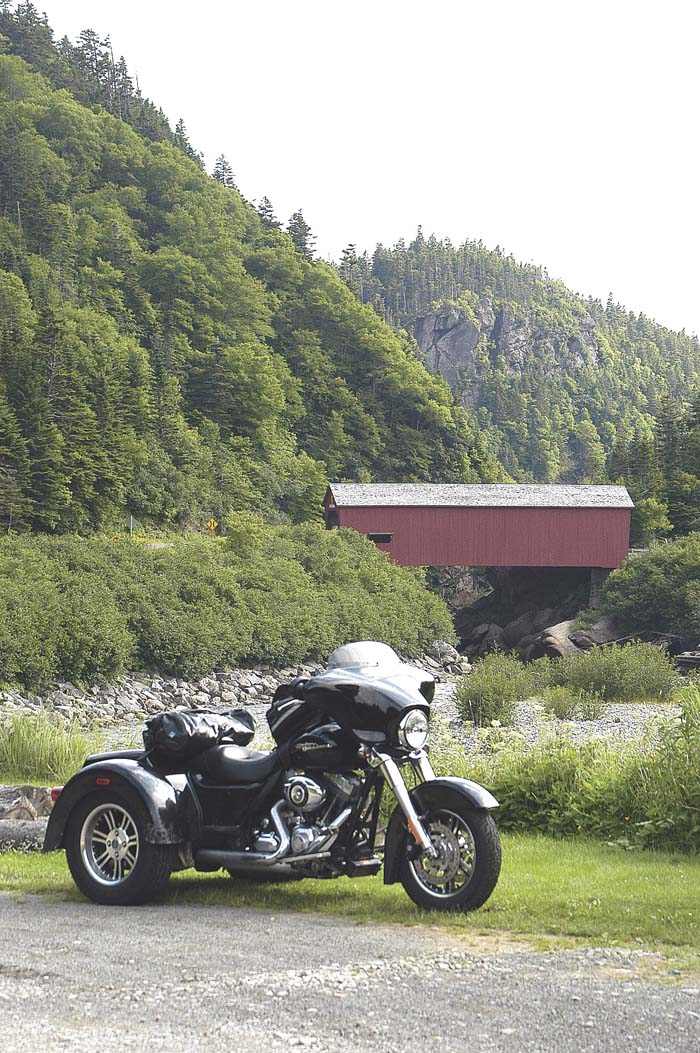
Lunch is the “world-famous” seafood chowder at The Caves Restaurant in St. Martins with a view of the sea caves. These are like horizontal potholes carved deep into the red sandstone by wave action. Riding back into the village I cross Vaugham Creek, the only place in Canada where it’s possible to photograph two covered bridges and a lighthouse in a single frame. It’s only 25 miles to Saint John, but the village store offers the last opportunity to fill the gas tank.
Saint John is a deepwater port and shipping has always been the heart of this city. Buildings reflect the mercantile sea trade of both the past and present. Giant gantry cranes along the wharfs of Saint John West testify that commercial shipping is a vital part of the local economy while the world’s largest cruise ships moor in the center of downtown.
I find my way to the bridge that spans the gorge of the Saint John River. I’ve timed my arrival to watch the turning of the tide at the Reversing Rapids. Twice a day the third-largest river on the Atlantic coast fights a Sisyphean battle against 25-foot tides. The ensuing maelstrom concludes with the rapids running upstream.
Next stop is Eldridge’s H-D (1230 Fairville Boulevard, 506.635.8707) where Austin Sleigh, the service foreman, cheerfully searches for their shop manual so I can adjust the parking brake. This brand-new Street Glide Trike isn’t mine: I borrowed it from Deeley, the Canadian importer in Toronto, and it would be nice to return the machine in working order.
There’s still much to see in this city so I book into the Hilton at Market Square and go out to savor the downtown street scene and explore the New Brunswick Museum.
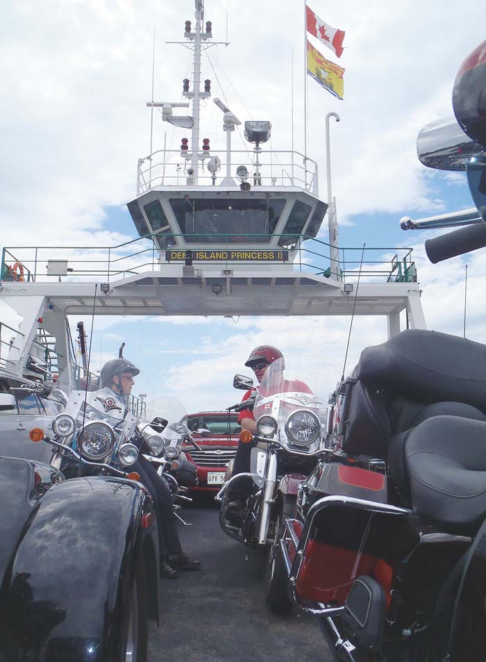
Gazing at the sky while enjoying the day’s first cup of coffee, I make the decision not to follow the Fundy Coastal Drive all the way to the Maine border at St-Stephen/Calais. Instead, I’ll cut down Route 172 and take the ferry to Deer Island. Once there the decision can be made as to which ferry crossing to take—the one to Campobello Island or the one to Eastport.
The crossing to Deer Island is free and it’s first-come, first on. This marks the western end of the Bay of Fundy, but there’s one last tidal phenomenon I wish to see. The Old Sow is the second-largest whirlpool in the world and it’s located in the channel between Canada and the United States. It turns out to be a disappointment, although I do see a number of “piglets” forming. I was told it has diminished since the causeway was built to Eastport, but can still be impressive during a spring tide.
I roll off the ferry into the easternmost city in the United States, passing a U.S. Navy missile frigate destroyer whose crew is in Eastport on shore leave. My Fundy ride is behind me; Downeast Maine lies ahead. I’ve returned to a familiar coast with a pulse that is less dramatic, but where people still time their lives by the ebb and flow of the tides.