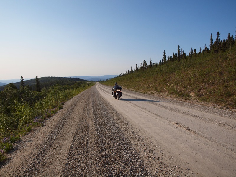
The ride from Whitehorse to Dawson was cold and wet. All I could think of was, “If it is raining on the Top of the World Highway there is no way we will ride it!” Top of the World Highway is hard-pack gravel with some short stretches of pavement on the Yukon side, but it turns to hard-pack dirt on the Alaskan side. When it rains on the Alaskan side the road surface turns to gumbo and it’s like riding on ice—not a good place for a heavy touring bike. Top of the World Highway has been called Alaska’s ultimate ride, while others call it “100 miles of hell.”
The idea for this ride started a year earlier with a group of three riders going to Alaska. My close friend Don was in from the beginning. I had put

the word out at the local Harley dealers that I was looking for riders. I received a number of emails, but the only one who was serious was a lady who asked if we had a problem taking a girl on the ride—her name is Sandi Tirey. She said she had lots of experience and that she would not be the girl on the ride. We weren’t sure what she meant by that statement, but after we all met to discuss the ride Don said, “She sounds OK to me.”
Fast forward to two weeks before our departure when Don contacted me and said he could not go since his mother was very ill. So that left just Sandi and me. After the first day of the ride I knew Sandi would be OK. The one highway I really wanted to ride was Top of the World Highway. I had talked to Sandi about it early on to make sure she was up for it and she said, “This ride is my birthday gift to myself and I want to ride every road we can.”
We rolled into the Bonanza Gold Motel in Dawson at about 5:00 p.m. It was still raining, but I had planned to spend two nights in Dawson. The next day we would spend time to rest up and tour Dawson, with the extra day giving us more time for the weather to clear. Dawson, located in the Yukon Territory, is the town of the 1898 gold rush with plenty of rich history.

The weather did clear the next day. I stopped at the visitor’s center in Dawson to check on road conditions and was told the road had been a mess for the past few days, but the word was that it was drying fast and should be fine by the next day. Sandi and I spent the day in Dawson relaxing and checking out all the history in this old boomtown. That night I asked Sandi again if she was up for the next day’s ride. She just smiled and said, “I told you I was not going to be the ‘girl’ on this ride.”
We were up in the wee hours the next morning since I wanted to get an early start. The only way to get from Dawson to Top of the World Highway is by putting the bikes on the ferry across the Yukon River to West Dawson where the highway starts. By mid-morning there is usually a long line of cars and motorhomes waiting to cross. Once on the ferry, Sandi was all smiles.
The road was paved as we left the ferry, but it quickly turned to gravel as we climbed to the top. We stopped to take a

couple of pictures of the sign thanking us for visiting Dawson. The road was in good shape and we could safely maintain a speed of 40 mph, but had to slow down on the many curves. I would check my mirrors on occasion to see how Sandi was doing and I swear I could see her smiling through her full-face helmet.
Top of the World Highway is literally on top of the world, as the road runs along the tops of the mountains. The view changes around every curve, and always for the better. You can see for miles in any direction, including the road ahead twisting its way across the mountains. We would pull over on occasion just to enjoy the view, and because it was early in the morning, there was little traffic so we could stop at just about any place we wanted. We also found a road grader working, which told me we would encounter some loose rocks, and sure enough, a switchback appeared in front of us with thick, loose gravel. I got through it pretty easily and then looked in my mirror to see Sandi doing her best imitation of dirt track racing. Fortunately, neither of us dropped our bikes.

When we got to the Forty Mile Creek area we found an abandoned miner’s cabin next to the road. Gold was being mined in the Forty Mile area before the big strike near Dawson in 1898. Sandi made the comment that the road was a lot better than she expected. I just smiled because I knew what was coming as soon as we crossed into Alaska. Once in Alaska, the road becomes the Taylor Highway and there is no longer hard-pack gravel—and I was just hoping the road had dried in the past two days.
We rolled into the Poker Creek checkpoint—the northernmost border crossing in North America. It’s only open in the summer from 8 a.m. to 5 p.m. After the usual questions and a short break we continued four miles to Boundary, Alaska. The road had turned to hard-pack dirt and about 30 mph was our top speed. The good thing was that the road was dry.
At Boundary we found what was left of an old mining community complete with the oldest standing roadhouse in Alaska. There was a small coffee and gift shop, operated by a fellow from Boston. He said he used to build motorcycles for a living, but decided to get away from it all and ended up in Boundary. This is about as far away as anyone could get, in my opinion.

After a cup of coffee at Boundary, we got back onto the highway. Just before Jack Wade, Alaska, the name of the road changes to Taylor highway. Our plan was to ride to Chicken, Alaska, but this would take a while since the road was rough with potholes. We just slowed down and took our time. Sandi was doing fine until I looked in my mirror and saw a dual-sport bike coming up on her fast. Every chance I got I would look back and see Sandi waving this guy back. She doesn’t like anyone following her closely and she was not going to let this guy pass and throw dirt and stones on her. He stayed behind her all the way to Chicken. Just prior to arriving in Chicken we met two tour buses headed for Dawson. I never expected to see a tour bus on this road considering how narrow and rough it can be in spots. Fortunately, they both slowed as they passed us so we did not have to eat any stones.
If you have never been to Chicken you need to go. Beautiful downtown Chicken, as the locals call it, is a step back in time. Gold was discovered

on Chicken Creek in 1898 and the town grew to a population of 400. Today there are about 50 residents in the summer and mail is only delivered twice a week. History recalls the miners who wanted to name the town Ptarmigan after the local game bird, but no one could spell Ptarmigan so they named it Chicken. The Chicken Mall consists of the Chicken Creek Gift Shop, Chicken Creek Saloon and Chicken Creek Café. You can also see the Pedro Gold Dredge, which was hauled in piece by piece from Fairbanks in 1959. We decided to have lunch at the Chicken Creek Café. A bowl of soup and a piece of fresh baked pie would hit the spot. Sandi just had to ask what the soup of the day was. The lady behind the counter replied, “The same as every day—chicken.” Everyone got a laugh at Sandi’s expense.
After spending time in Chicken we headed south to Tok, Alaska, where we would spend the night. About two miles out of Chicken the road went from dirt to paved. Well, almost… there were still some sections of gravel. About halfway to Tok the rain started—I guess our timing was right. We were both glad the rain held off until we hit pavement and checked in at the Snowshoe Motel for a well-deserved rest. That night at dinner I looked at Sandi and said, “You know, you have done today what few women have. You rode Top of the World Highway on a heavy dresser.” Sandi just smiled and said, “Yes!” 4
Resources
The Milepost
www.themilepost.com
800.726.4707
Alaska Tourism
www.travelalaska.com
480.483.1551
Yukon Territory
www.travelyukon.com
800.661.0494
Bonanza Gold Motel Dawson, YT
www.bonanzagold.ca
888.993.6789
Snowshoe Motel Tok, AK
800.478.4511

