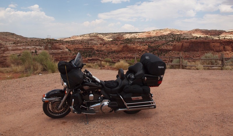
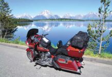
I have ridden the Utah Canyonlands many times and will never get tired of the scenic landscapes around every curve in the road. Any rider who has ridden this part of the country will tell you places like Zion and Bryce Canyon National Parks are tops. They will also tell you Arches and Canyon Lands National Parks are magnificent to behold and I cannot disagree, but there is so much more of Utah if you get off the beaten path and head for the roads less traveled. This is a story of three of those roads: Highway 12, the All American Road; Highway 24, Capitol Reef Scenic Byway; and Highway 95, Trail of the Ancients.

Highway 12 begins at Highway 89 north of Zion National Park and west of Cedar Breaks National Monument. If you look at your map it shows Highway 12 as the route to Bryce Canyon. After passing through Red Canyon just off Highway 89 on Highway 12, I travel on to Bryce Canyon. Most tourists reverse course at Bryce, but for this rider, this is where my ride really begins.
I would not stop at Bryce this day, since I knew what was awaiting me farther down the highway: less traffic, hundreds of miles of winding road and ever-changing scenery. After passing Bryce I ride on to Cannonville. There’s not a whole lot in Cannonville, but it is where you turn south to Kodachrome Basin State Park. Kodachrome Basin is a hidden jewel that most miss if they travel this area. It is a short 12 miles to the park with some great views along the way. The park is small, but the rock formations you will see are worth the ride. There’s also a nice camping area here, if that is your thing.
After a short stop I am back on Highway 12 headed for Escalante over Summit Pass, riding along Upper Valley Creek and taking in the view. At Escalante I stop for lunch and meet two riders from Germany who had rented Harleys in Las Vegas. After lunch it was time for the most scenic and fun part of Highway 12: the Grand Staircase. The Grand Staircase begins in Arizona, climbing steadily north to Capitol Reef National Park via a series geological steps presenting a rainbow of colors. After leaving Escalante the road starts to climb and in minutes I am on top of the some of the most breathtaking country in the world. I stop at the Head of Rocks Overlook and just take in the view.

When I leave the pull-off, the road twists and turns with some nice switchbacks and grades towards Calf Creek. I ride through the Calf Creek Canyon and then start to climb back up onto higher ground that offers more views of the Grand Staircase. I then pass Calf Creek Falls, but you will have to get off the bike and walk to the falls if you want to see it. After the falls the road starts to climb again and soon I am on the Hogback. You will know when you are on the Hogback because the road narrows, the guardrails are gone and you will be riding on a sheer ledge with a drop of hundreds of feet on both sides. I make sure my eyes are on the road! At the top of the Hogback are a couple of small pull-offs, but I use caution since they are narrow and gravel.
A short distance after topping the Hogback I ride into the town of Boulder and Anasazi Indian State Park. This is a good place to have lunch and gas up, but I choose to visit the park headquarters and take a tour of the ancient ruins just off the road. If you want to get farther off the beaten path, you can turn off on the Burr Trail road for some great scenery. The first 17 miles of the trail is paved, so you will want to turn around and head back to Boulder when the pavement ends. After viewing the ruins it is time for me to head north and see a completely different Grand Staircase.
Farther north are Dixie National Forest and Boulder Mountain. Highway 12 starts a steady climb over Boulder Mountain, topping out at 9,600-foot Summit Pass. The cool mountain air is a pleasant change from the 100-degree temperatures of the canyons. The pass also gives me some great views of the canyon lands below. A word of caution if you ride this area: There is a heavy population of deer along the road, especially in the early morning and late evening, so take it slow and be vigilant.
After crossing Boulder Mountain I arrive at the town of Torrey where Highway 12 meets Highway 24. Torrey sits on the edge of Capitol Reef National Park and is a great place to spend the night and gas up if you are not going any further that day. I visit the park and then head on to Hanksville for the night. After Torrey, Highway 24 enters Capitol Reef National Park and I am back into the Canyonlands. Capitol Reef National Park is a park less visited, but well worth the ride.
Highway 24 follows the Fremont River Canyon, passing Twin Rocks and Chimney Peak with the park visitor center a few miles up the road. At the visitor center you can turn off and ride the scenic park road for nine miles. You will pass the Moenkopi formation, consisting of red sandstone layers, and then continue on to Capitol Gorge at the end. Capitol Reef is sometimes called the Water Pocket Fold, as it’s actually a geological fold in the earth. The Navajos called the Capitol Reef area the Land of the Sleeping Rainbow, because of the brilliantly colored canyon walls. Whatever you call it, it is a fun ride. After leaving the visitor center I pass the old Fruita Schoolhouse built in the late 1800s and travel along the Dirty Devil River through the canyon.

I have 30 miles to go to get to Hanksville, one of my favorite stops. Hanksville has a population of about 200 and was a supply stop for Butch Cassidy and the Sundance Kid since it was near their hideout, Robbers Roost, southeast of town. There is not much in Hanksville, but the Whispering Sands Motel is a great place to stay and the Red Rock Restaurant has excellent food. The most photographed place in town is the Hollow Mountain General Store and Gas Station across the highway from the Whispering Sands and the intersection of Highway 95. After a good meal and night in Hanksville I fill my tank up at the Hollow Mountain Gas Station.
From Hanksville there are no services until you get to Blanding. This is a very remote 121 miles with hardly any traffic—just the way I like it. The first 25 miles is open desert, but this changes rapidly when you enter the Lake Powell Recreation Area. The road follows Burr Wash and passes the Hog Springs rest stop and North Wash Canyon with good views of the cliffs and rock formations. A little farther on is the Lake Powell Overlook, a good place to stop and take in the surrounding area. From the overlook the road passes through pillars of rock to the bottom of the northernmost part of Glen Canyon. I cross the Dirty Devil River Bridge where it empties into the Colorado River and Lake Powell. The highway then takes me across the Colorado with some really great views of the canyon. Highway 95 has few sharp turns with mostly long sweepers. My next stop will be Natural Bridges National Monument. The road opens up after leaving the Glen Canyon area, but is still very scenic as I pass Fry Canyon and Jacobs Chair Mesa.

I pull into Bridges National Monument with the sky darkening and lightning appearing over some of the mesas. I had intended to ride the loop road to some of the bridges, but instead I decide to push through to Butler Wash Anasazi Ruins and Mule Canyon, and then on to Blanding. As I leave Natural Bridges National Monument the sky opens up, but in this area I know the rain will not last very long. As I arrive at the Butler Wash Ruins the sun is shining again, but after the rain the humidity increases and I decide not to make the half-mile walk to the ruins.
As I head farther east the road descends to cross Butler Wash and then climbs back up along the sheer cliffs above it. As I top out the road cuts through the rock and then drops off on the other side. The area from Butler Wash to Blanding has the sharpest turns and grades, offering a pleasant change from the big sweepers. Finally at Blanding, I pull in to gas up and enjoy a cold drink.
Thinking back, I wasn’t sure I actually saw the Sleeping Rainbow—or did I? I began to realize that the whole ride was, in fact, a rainbow of color from Red Canyon to Kodachrome Basin over the Grand Staircase to Bridges National Park and 121 miles of Highway 95. I realized that I did indeed see the Sleeping Rainbow; I just did not know it at the time. You just might find the Sleeping Rainbow if you are willing to get off the beaten path and follow the roads less traveled.

Resources
www.utah.travel
www.utahcanyoncountry.com
www.scenicbyway12.com
www.hanksville.com
www.whisperingsandsmotel.com

