As a child growing up in northwest Ohio, I thought all roads were straight, flat and had a cornfield on both sides. In my adult years I have been fortunate enough to have been able to ride in 49 states and most of Canada, traversing some of the greatest motorcycle roads on the map. One of the most heralded roads in the U.S. is Highway 129, the Tail of the Dragon, which I have ridden many times. Of course, when riders get together one of the things they talk about are the roads they have ridden or plan to ride. During many of these conversations the Ohio Tail of the Dragon came up, but it seemed there was a lot of disagreement on exactly which road it was. Some said it was Highway 78 from Caldwell west to Glouster. Others said it was Highway 555, the Triple Nickel from Ringgold to Highway 7 on the Ohio River, and yet others said no, it was Highway 536 from Highway 78 to Hannibal. My quest was to ride these roads and any others I could find and rate them on a scale of 1 to 10 with 10 being on par with Highway 129, the original Tail of the Dragon.
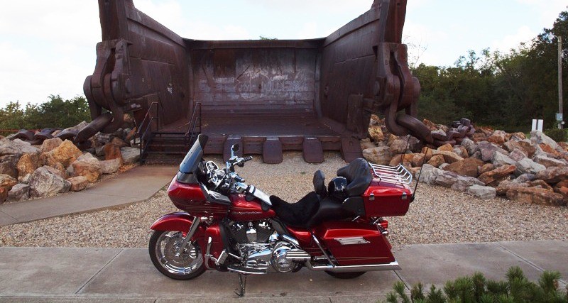
Leaving my home early I rode I-77 to Highway 78 at Caldwell and headed west toward Glouster. Highway 78 twists and turns through southern Ohio coal country much like West Virginia. As I rode I found 78 was somewhat like a roller coaster, following the contour of the hilly country with a number of S turns and elevation changes. The elevation changes were not steep grades, but those blind humps that you can’t see over until you reach the top. It seemed every time I topped of these humps there was a tight turn just on the other side. I learned quickly to slow down. About 17 miles west of Caldwell I came to Miner’s Memorial Park. After pulling in to the park I could see “Big Muskie’s Bucket.” Remember, I said this is Ohio coal country. Built in 1969, the Big Muskie excavator could move 39 million pounds of earth in one hour, opening up rich coal deposits just below the surface. The Big Muskie was the largest machine of its type in the world and was used until 1991 when all production stopped. In 1999 it was slated for the scrap pile and now only its massive bucket remains as a memorial to the miners who worked here. This is well worth the stop, if only to have some idea of how massive this machine must have been.

Leaving the park I continued on Highway 78 to McConnelsville. This town, settled in the early 1800’s, thrived on the coal mining in the area until the strip mines closed down. In the middle of the town square is a statue of a Civil War soldier honoring those who served. I am told McConnelsville is where oil was first discovered in North America, but saw no signs of any oil wells so I continued on with my quest to discover Ohio’s Tail of the Dragon. Leaving McConnelsville the curves started to get tighter, with some great scenery. As I continued on to Glouster I thought that this road does not equal Highway 129, but it sure was a fun ride. After riding the final miles to Glouster I stopped for gas, a coffee and to check my map. In Glouster there is a mural on the side of an abandoned brick building depicting the coal mining days and steam locomotives that transported the coal. After a few pictures I backtracked east on 78 to Ringgold and turned south on Highway 555, the Triple Nickel. Would this be the Ohio Dragon? The Triple Nickel started out with lots of promise. The road immediately started to climb with some steep elevation changes and sharp S turns. The land next to the road was thick forest like Highway 129. Have I found the Ohio Dragon? After about three miles of riding the country opened up to farmland, but still there was a lot of winding road ahead of me. I enjoyed the scenery and all those twists and turns the Triple Nickel had to offer. A word of caution is in order. Many of the curves have gravel thrown up from the berm, but it should not pose a problem for any rider who stays alert. This is truly a road any rider will appreciate.

I continued to the end of the road at the Ohio River and then rode north on Highway 7 to Marietta for lunch. During lunch I looked over my map and saw Highway 26 and decided to head north on 26 from Marietta to see what I could find. Highway 26 follows the Little Muskingum River Valley. I was glad I decided to ride this road; although there are not a lot of elevation changes, it does twist and turn along the river, making for a relaxing ride with lots of scenery. It was not long before I came to the Hune Covered Bridge. The road leading over the bridge is gravel and, since I did not know where it led, I chose not to ride over the bridge and instead took a few pictures.

A little further on, I came across the Rinard Covered Bridge. This bridge is closed to all but foot traffic. At this point I continued on to the town of Woodsfield, all the time enjoying the scenery and century-old farm homes along the way. At Woodsfield I made a right and was back on Highway 78, but then headed east to Highway 536, my last chance to find the Ohio Dragon. Highway 536 is only 10 miles in length to where it ends at Hannibal and the Ohio River. I found a road with little traffic that for the most part runs along the hilltops with a lot of twisting and turning, not giving the rider much time to relax between turns. What a fun 10 miles. About a mile from Hannibal I got a view of the town and Ohio River below before the road descended to the valley with one switchback before I reached the valley floor. Had I found the Ohio Tail of the Dragon? This was by far the closest I had come in my quest. Highway 536 does not have as many curves as the Tail of the Dragon, but it is one good road that I will ride again when I’m in the area. At Hannibal I stopped at the Hannibal Locks and Dam hoping to see one of the many barges passing through the locks, but my timing was wrong. The Hannibal Locks and Dam is at the intersection of Highway 536 and Highway 7, the Ohio River Road, and is always worth a stop. I continued on just across the river to Moundsville, West Virginia, to spend the night and head for home the next day, but there is one more highway that deserves honorable mention: Highway 250 heading north from I-70, just across the bridge from Wheeling, West Virginia. From here to Cadiz, Ohio, Highway 250 offers the rider lots of elevation changes and sharp curves with a few switchbacks thrown in. From Cadiz on, the highway straightens out with some nice sweepers and scenery while passing Tappan Lake on the left. Looking back, I would rate Highway 78 a 7, Highway 555 a 7.5 and Highway 536 an 8. South of I-70 and east of Zanesville there are also many roads to explore that I did not have time for, but plan to in the future. All one has to do is look at a map and start riding and I’m sure you will find the best riding in Ohio. If you are passing through and don’t get off the main highway to explore some of these southern Ohio roads, you are missing a lot of good riding—even if you never find the Ohio Tail of the Dragon. Resource: www.roadsideamerica.com







Thanks, your article was very informative. I am planing some rides for our group. We are retired Navy Divers and hoping to find the Dragons Tail. Thanks again and safe riding…
I have riden alot of Ohio in 45 years I don’t think I have missed many roads in southern ohio that’s the way I always ride from my home in New Holland,some 40 miles south of Columbus.There is some nice riding up north but they are hard to find.I usually get on 555 in Zanesville and go all the way to the river,93 is also a very scenic route and 73 from Portsmouth to Hillsboro.From the Ohio River to Lake Erie Ohio in the Fall is one of the most beautiful places to ride.If you ever get to Laurelville just at the edge of town is a road call Thompsons Ridge it will test your ability as a rider,don’t mind it when your running boards drag it will be ok,peace and ride safe
9/6/16. Just rode 536 from ohio 7 to ohio 78 near woodsfield. Very nice ride. Definitely very curvy.
Coming off the river the road was patched but smooth. Once on top it’s brand new asphalt that was a little slick at 88 degrees. There are 2 spots that are one lane where they are working on slips.
I’m definitely going back but will wait till the asphalt gets some of the oil washed off.
Give Ohio 799 a try. south of deersville ohio, on the back side of tappan lake. It’s definitely a fun drive, lots of curves, a few blind hills, and plenty of challenging elevation changes. The other fun one is Ohio 93, south canal fulton. From there all the way down to 36, is a pretty fun and changing ride.
grew up on a farm on ohio state rt 536, and began riding on the road at age 13. I still love it at age 70.
Crazzy lived off Route 555 outside of chesterhill Ohio almost to Elliott Crossroads Ohio 555 Route 44 intersection.
We had no crazzy flying down the roads like yall do today.
Round many miles on my Bicycle( road racing)