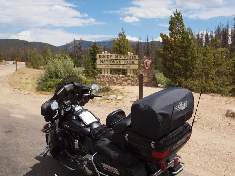
Fires are raging near Ft. Collins and Colorado Springs and the temperatures are in the 90s. I’m riding Trail Ridge Road in Rocky Mountain National Park at over 11,000 feet in jeans and a T-shirt. This is how my Colorado ride started.

My plan was to ride as much of the Colorado High Country as possible, while visiting as many ghost towns as possible (Colorado has over 200) in the time I had. Instead of entering Rocky Mountain National Park from the east, I rode south from Wyoming on Highway 125 to Granby and then took Highway 34 to enter the park from the west—all because of the forest fires near Ft. Collins. The winter had been dry with little snow and spring rain in the mountains, and Colorado was a tinderbox.
After exiting the park I rode south on the Peak to Peak Highway. Highways 7 and 72 make up Peak to Peak Highway. The highway parallels peaks of over 14,000 feet with great views around every curve. I was headed for Black Hawk and Central City to visit my first ghost town, Nevadaville.

Black Hawk and Central City have been restored and, with the casinos moving in, have become a regular tourist stop. Leaving Central City to the south, I turned onto Nevadaville Road. Looking at the abandoned buildings takes you back to the mid-to-late 1800s. There are two types of ghost towns: the semi-ghost town that still has some inhabitants, but nowhere near the population during its peak; and the other type of ghost town that is completely abandoned. Nevadaville still has a few residents, but not the 1,500 that once lived here. During the gold and silver rush around 1850, towns sprang up near mines all over the state and, when a mine played out, most of these towns were abandoned. After Nevadaville I spent the night in Idaho Springs, a few miles down the road. The next day would be spent riding the High Country.

Riding the highest paved road in North America at over 14,000 feet, I took Highway 103 south from Idaho Springs where it intersects with Highway 5, better known as Mt. Evans Road. This is one road you need to use extreme caution on, as it’s narrow with no center or side markings and no guardrails. The word “switchback” has meaning on this road, and I was required to use both lanes on many of them—you must be sure there is no oncoming traffic when you negotiate these twisties. It’s 15 miles to the top, with few places to turn around if you lose your nerve. At nine miles is the Summit Lake pull-off. After leaving Summit Lake I found the last six miles to be the most demanding, but once at the top, it was worth the ride and the view was magnificent.

The descent was as demanding as the climb to the top. At Idaho Springs I took I-70 west to Georgetown for my ride over Guanella Pass, which most riders don’t know of. The 22-mile road takes you over the pass and into the town of Grant. At the top there is a parking area with some great views of the surrounding mountains. I left the parking area and started my ride down the south side of the pass. The last three miles was hard-pack gravel in good condition with no sharp turns, which posed no problem for me on my Ultra Classic.
At Grant I turned west on Highway 285, which took me across Kenosha and Red Hill Passes and then on to Fairplay. At Fairplay is South Park City, which looks like a typical 1800s mining town and included many original buildings relocated from nearby ghost towns. You can take a self-guided tour if you wish, but I decided to move on and ride more of Colorado’s great High Country.

Riding north on Highway 9 about six miles you come to Alma. Alma is a semi-ghost town with a general store and a couple of bars that are still open. (Many of the buildings at South Park City were moved from Alma.) I stopped for a couple of photos and then headed north across Hoosier Pass to Breckenridge. We know Breckenridge today as a modern community and ski resort, but Breckenridge was also a mining town in the 1800s, as were well-known towns like Aspen, Steamboat Springs and Telluride. These towns, and many more like them, survived for one reason—World War II and the army’s 10th Mountain Division. The 10th trained at Camp Hale, north of Leadville, and fought their way through the mountains of Italy in 1944 and 1945. After Breckenridge I rode north to I-70 and then west to Vail, where I turned south on Highway 24. Highway 24 is known as Top of the Rockies Highway, but you can ask anyone in the area and they will tell you it is the 10th Mountain Division Memorial Highway.
Riding the 10th Mountain Division Memorial Highway cannot be beat. My goal was to visit what little is left of Camp Hale and the 10th Memorial. There was little to see in Camp Hale save for a placard with a picture showing the camp in 1944 when over 10,000 soldiers were stationed there. After stopping at the memorial I continued to Leadville at over 10,000 feet to spend the night at the Alps, a great little mom-and-pop motel. After checking in, it was time to stop at my favorite watering hole, the legendary Silver Dollar Saloon.
The Silver Dollar was built in 1879 and opened as the Board and Trade, a drinking and gambling establishment. About half of the original buildings in Leadville were destroyed, but the Silver Dollar is original. When you walk in, it’s a step back in time, but still serves excellent food and the coldest beer around. Today Leadville has a population of less than 3,000, but in the late 1800s it was second only to Denver. After the gunfight at the O.K. Corral, Doc Holiday came to Leadville to gamble—and he also shot his last man here. From Leadville I rode south on Highway 24, passing the Valentine abandoned mine and on to Nathrop, where I turned onto County Road 162 for the 15-mile ride to St. Elmo ghost town.

After some photos at St. Elmo I returned to Highway 24 and backtracked north to Winslow and Victor ghost towns, north of Buena Vista. After a quick stop I went north and then west on Highway 82 over Independence Pass at over 12,000 feet to Aspen, with a stop at Independence ghost town on the west side of the pass.
At Carbondale I turned on Highway 133 south, and 17 miles later is what’s left of Redstone and the coke ovens from 1800s coal mining in the area. A few more miles south I came to where the largest marble quarry in the world was once in operation. (The marble for the Lincoln Memorial and Tomb of the Unknown Soldier came from here.) You can no longer get to the quarry, but you can stop at the Slow Groovin’ BBQ for a great lunch, as I did.
Continuing south to Hotchkiss I turned west on Highway 92 for the ride along the north rim of Black Canyon of the Gunnison National Park. This is a rider’s road with lots of twists, great scenery and, of course, spectacular views of Black Canyon. Highway 92 ends at Highway 50 and Blue Mesa Lake. Heading west along Blue Mesa Lake takes me to Highway 149 and Lake City, where I spent two nights drying out from the rain I encountered. After staying at the Town Square Cabins it was time for something completely different—I had called ahead and reserved a Jeep from Lake City Auto & Sports Center. Yes, I’m going to trade my two wheels for four.

I not only wanted to ride as much of Colorado’s high country as possible, but I also wanted explore as many mining/ghost towns as possible. The Alpine Loop that begins in Lake City is a back-country road over the San Juan Mountains requiring a 4×4 or a dual sport bike. You cannot make it on your Harley, unless you want to bring it back in a basket. Following the Loop will take you past many abandoned mines and what is left of the towns around them. The first part of the road is hard-pack gravel and I wondered why I needed a 4×4?
Not far up the road is Hard Tack Mine, which offers tours from 10:00 a.m. until 5:00 p.m. At one of the mines I met two riders from Toronto on dual sports. I stopped and talked to them and they suggested I follow them since they would be faster. From here the road got narrow and much rougher, as we passed Whitmore Falls and then stopped at the Capital City ghost town. We finally made it to the top of Engineer Pass at over 12,000 feet—and now I know why I had a 4×4. If you want to do something different on your next ride to Colorado rent a 4×4 and drive the Alpine Loop—you will be glad you did.
The next morning I headed south over Slumgullian and Spring Creek Passes on my way to Creede. Creede is a popular stop for riders and another one of those mountain jewels that has been able to survive on tourism after the closing of the mines. After a cup of coffee at Creede I continued on to South Fork riding through Wagon Wheel Gulch along the Rio Grande River. At South Fork I turned west on Highway 160 and on through Pagosa Springs to Durango.
At Durango I headed north on Highway 550, The San Juan Skyway. If you only have time to ride one road in Colorado, I would recommend this Highway. It is one of the most scenic rides you will find in North America. You will ride over Coal Bank and Molas Passes on your way to Silverton. Silverton is rich in mining history and has something for everyone. You can get your Harley T-shirt at the highest Harley store in the country, or take a stagecoach ride around to town. Of course, if you want to get off the bike you can get on the Durango Silverton Railroad in Durango and ride the train to Silverton. Either way, Silverton is a must stop.
Leaving Silverton I rode north to Ouray stopping at Red Mountain Pass and mining district. There is a nice pull-off there where you can view the Yankee Girl Mine, once the richest mine in Colorado. From Red Mountain, the highway to Ouray gets narrow with no guardrails, but it’s the most spectacular part, in my opinion. This section is called the Million Dollar Highway, and it’s said it was built at a cost of $1 million per mile as a supply route to Silverton during the mining boom.
After a quick stop for a photo or two in Ridgway, I rode west on Highway 62 to Placerville. The 1800s Placerville Post Office is for sale, the old general store is still open and that’s about it. From Placerville I head south on Highway 145, past Telluride over Lizard Head Pass and on to Rico. After a short stop I continued on to Cortez for the night and the end of my Colorado adventure.
As I sit in my motel room with a cold one in my hand I look back at the past five days and think about what I missed—not much! In my mind, Colorado is a rider’s paradise offering just about anything the touring enthusiast could imagine; mountain peaks, canyons, fast-flowing rivers, ghost towns and, of course, some of the best roads in the country. Go ahead and plan your next ride to Colorado. You will glad you did.
Resources:
www.colorado.co
www.ghosttowns.com
www.lakecity.com
www.visitleadvillecolorado.com
www.hardtackmine.com
www.alpsmotel.com
Lake City Auto & Sports Center, 970.944.2311


