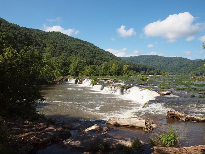
This particular expedition began on a good note since the day before when a group of friends and I had ridden 300 miles in constant rain while crossing North Carolina. But today the sun was shining as we left our motel in Princeton, West Virginia, and the weather forecast was identical for the next two days. (The way this ride concluded is another story, but I will get to that later.) We left Princeton on Highway 20 North, a great road running through miles of the West Virginia backcountry. A few miles north of Princeton Highway 20 runs along Bluestone Lake, eventually passing the Bluestone Dam on the New River and then crosses the river at Hinton. To cross the bridge you need to make a right turn, otherwise if you continue to ride straight, the road will take you to Sandstone Falls State Park on the New River.


The trek to the falls is a narrow, paved strip with a pull-off a few miles up the road. That’s where we parked the bikes and walked the wooden walkway to the river and falls. The falls are ever-changing depending on the amount of water flowing, and from the walkway you’re allowed a great panoramic view. After spending some time taking pictures and relaxing, it was back to Highway 20 North and the New River Gorge. The road twists and turns along the gorge until you get to the New River Bridge on I-64. I was told they close one side of the bridge each year so base jumpers can jump and glide to the bottom several hundred feet below—think I’ll pass on that one.
After the bridge, 20 winds through the valleys and climbs over a few mountains with some sharp curves and steep grades tossed in to keep your interest level high. If you ride this road expect to get behind some heavy logging and coal trucks, as we did, since these are the two primary industries in the area. Traveling through the West Virginia backcountry brings many thoughts to mind. What was it like 100 years ago with no paved roads and a much slower pace of life? At the little town of Nettie we head east on Highway 55, the Highland Scenic Highway and into the North Bend Recreation Area. Highway 55 gets little traffic and is lined by forest and small streams. As we travel on we enter the Cranberry Glades Botanical area. This area boasts the largest population of black bears in the state, but as luck would have it, we saw no bears on this day. If you are there in May or early June, I recommend taking the Cranberry Glades turn-off. During that season, at the parking area a boardwalk will take you through a forest of flower-laden rhododendrons. After passing the Glades the road has some more steep grades and sharp turns any rider will love.

At the intersection of Highways 55 and 219, I turn our group north to Marlinton. The road to Marlinton climbs over the mountains with lots of sharp turns and switchbacks, although I liked it much better a few years back before it was widened and repaved. The old road was a lot more demanding, but the road today is still a great ride. After a short stop for lunch and gas in Marlinton, it was a short ride on 219 North to Highway 66 East. Highway 66 East takes you to the old coal town of Cass and the Cass Scenic Railroad State Park, but before going to Cass we turned off on the loop that takes you to Snowshoe Ski Resort. The road to Snowshoe is another one of those roads that offers the rider lots of twists and turns. After twisting our way off Snowshoe Mountain we turn back onto Highway 66 and into Cass.
Cass was an early 1900’s coal town. The Cass Railroad was built to transport coal from the mines to the valley and on to its final destination in the east. Today the old company store and offices remain fully restored for visitors to see. On most days the Cass Railroad still operates, taking visitors on a steam train ride through the mountains. On the day we were there the train was not operating, but it was available for viewing and taking pictures. Visitors are allowed to climb on board the locomotive for pictures. After everyone had a chance see what Cass was all about, it was time to head east on 66 and then Highway 28 North to Romney. Highway 28 runs through the valley for the most part, and is a very relaxing ride through forest and farmlands. Along the way we stopped at the National Radio Astronomy Observatory. I was told the observatory sends radio signals into outer space and listens for replies. Aliens, anyone? I wondered if I were to plug my smartphone into one of the giant radio antennas who I might contact.

Further north is Seneca Rocks State Park. This is a good place to take a break and view the face of the mountain and sheer cliffs, i.e. Seneca Rocks. From here it was onto Romney, the oldest incorporated town in West Virginia. I always stay at the Koolwink Motel when I’m in Romney. The Koolwink is biker friendly with reasonable rates. After a good night’s sleep we were headed west on Highway 50. If you tried looking at a map to determine what roads offered the best riding in the area you most likely would not pick Highway 50. Let’s face it; it’s a major highway running from coast to coast. But let me tell you that from Romney to Grafton, Highway 50 is one fun road to ride, offering an abundance of steep grades (and I mean steep) along with sharp curves and challenging switchbacks. Plus the views of the mountains and valleys along the way can’t be beat. Passing Grafton the road flattens out and we turn north on Highway 250 to Wheeling.

Once past the City of Fairmont, Highway 250 turns into a backcountry highway. Like Highway 50, Highway 250 offers the rider a little of everything, but it’s more remote and less traveled. I have always thought of 250 as the highway of the past since so many of the small towns along the way have seen better days. Since the pottery and coal industry moved out years ago, the towns have been left to survive on their own. As you ride through these towns you will see abandoned buildings and crumbling structures from the past boom years. One town I always like to visit is Cameron. Cameron still survives, but is not what it once was when it sprang up, centered around the pottery industry. In downtown Cameron you find some small businesses still hanging on. A sign from the past is a three-story high Mail Pouch Tobacco sign painted on one of the old buildings. How many people remember seeing these signs on barns and buildings back in the day?
After leaving Cameron it was more steep grades and sharp turns until 10 miles south of Wheeling where 250 becomes a four-lane highway and intersects with I-70 crossing the Ohio River. We would cross the river and then head north to our homes in northeast Ohio. As we approached Wheeling I could see dark clouds and lighting ahead so we pulled over and put on the rain gear. I just knew we could not go two entire days without rain, but we were all experienced riders and said, “Oh well,” and continued on. Remember at the beginning of this story I said, “The way this ride ended is another story?” As we approached the bridge over the Ohio River, the rain began in earnest and included plenty of thunder and lighting. No big deal—we have ridden in weather like this many times.

After crossing the bridge we had to exit to the right back onto 250. I put my left hand up to signal the right turn and bang! It was like a cannon had gone off next to me. My left arm felt like someone had thrown a punch and hit it. I was pushed forward on my bike almost hitting my chin on the tank. It was a bolt of lightning that had struck. I was able to recover and make the exit ramp. I looked in my mirror trying to see if anyone was down. I saw one rider kind of slumped over, but still up as were all the others. I made the right turn off the Interstate and fortunately there was an available gas station where we could pull in. At this point my arm was tingling and my eyes were spinning like a pinball machine. As I tried to step off the bike my legs were weak but I was able to stand. Clearing my head I saw the others gathered around another rider sitting down. He had been hit harder than I and needed some time to clear his head. After a 30-minute rest we all seemed to get our bearings, but my arm still tingled and I had a severe headache.
All I could think of was, what if that lightning bolt had struck a few seconds later when we were stopped at the top of the ramp with our feet on the ground? The outcome would have been a lot different. From there it was a somber ride home, but we were all thankful to be alive that day. On a lighter note, one of the guys told me later that every time he turns his radio on now, it’s instantly locked onto the Wheeling station he was listening to when we were zapped by that bolt of lightning, no matter which frequency he had previously tuned in.
West Virginia offers great riding that any motorcyclist would love. You cannot beat the roads and scenery, but don’t end your ride like I did. When the lightning show begins, take cover, relax awhile and think about the great riding that is still in front of you.
Resources:
www.koolwinkmotel.com
www.visitwv.com
www.snowshoemtn.com/events-and-activities/summer-activities/motorcycle-touring.aspx


