Riding down the Walloostook
A journey from the Republic of Madawaska to the port of Saint John
Saint John, N.B.— Riding down the Walloostook I see storm clouds on the horizon. There have been storms here before, most notably during the Aroostook War, that forgotten conflict that almost caused a third war between the U.S. and Great Britain. It’s an interesting story about company greed, commodity speculation, conflicting territorial claims, refugees and extremist groups escalating disagreements to the point of armed conflict. It could make headlines today if you substituted the word “oil” for “lumber,” but this took place in the 1830s. Anyway, the people living in this beautiful valley got tired of the outside political bullshit and declared themselves to be the independent Republic of Madawaska. It got everyone’s attention and the international border of Maine and New Brunswick—as well as those for New Hampshire, Michigan, and Minnesota—got hammered out in Paris as a treaty in 1843. However, the Republic of Madawaska still exists, encompassing both sides of the border and with the title of President being traditionally bestowed upon the mayor of the city of Edmundston.
I’m trying to catch the end of the annual Jazz & Blues Festival, but am hours behind because I spent the night aboard a military submarine, the HMCS Onondaga, on the shore of the St. Lawrence River. As it begins to rain, I pull into the parking lot of the Antique Automobile Museum on the outskirts of Edmundston, New Brunswick.
It’s a quick stop. I just want to take some photos and inspect the Bricklin. However, I get sidetracked by an REO (the car, not the rock group) and a Detroit Electric (yes, Detroit was producing electric cars from 1907 to 1923), and then by the 1933 Rolls-Royce Phantom and the pristine 1928 Ford Model A. Before I realize it, time has passed and the rain has become steady.
Wearing a 100-percent waterproof Transit leather suit has made me oblivious to inclement weather, and mounted on a Street Glide Trike borrowed from Deeley Harley-Davidson, I could care less about wet pavement, so I depart to catch the last of the festival. Alas, it isn’t to be. I sit out a deluge beneath the Route 2 overpass as the worst storm of the last two years rolls through. By the time it lets up enough for me to escape to downtown, the festival has disappeared like street litter down a storm drain.
New Brunswick is officially bilingual, but regardless of which side of the border you’re on, the primary language is Canadian French, with Acadian being just a bit more in common use than English. Fortunately, official signs are posted in both French and English.
Walloostook was the name the Maliseet Indians gave to the great river, the second largest on the Atlantic coast. The French settlers renamed it the Saint John. When the British gained control they decided Saint John was easier to pronounce than Walloostook and besides, they didn’t want to have to redo all the established maps.
Route 144 takes me to Grand Falls/Grand-Sault, the only town in Canada that’s officially in two languages. Here a gorge 270 feet deep snakes through the center of the city and the waterfalls the First People called Chicanekapeag, the Great Destroyer, has been tamed by a hydroelectric dam. I end up competing for the best photographic vantage points with a busload of Japanese tourists before riding the trike around—not across—the great gorge.
It’s an old river road, one that follows the natural undulations of flowing water at a meandering pace. The asphalt is broken, patched and re-patched. Vegetation grows to the very edge of the pavement and often arcs overhead to embrace the opposing side, forming a dappled tunnel of refreshing shade. The few people I do see in passing all raise an arm in acknowledgement or wave a greeting. This is Route 105 and I don’t have time for the fast-paced traffic on the other side of the river. When I stop to take a photo, no cars pass me; there’s nobody on my tail.
My first night is spent in a stone castle and my host at this inn is a Scottish chef who stocks cold Irish beer and has a passion for English-Indian fusion cooking. In fact, the farther I travel down the river, the more English it becomes.
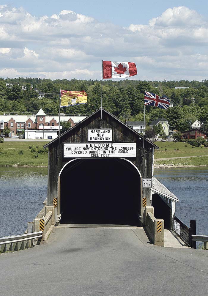
The bridge across the Saint John River at Perth-Andover is steel girder construction. The next one, in Florenceville, has one span as a covered bridge and the remaining ones are girders painted lead green. The third one, the one I’ve traveled especially to see, is the world’s longest covered bridge in Hartland. At 1,289 feet in length it’s almost a quarter-mile wooden tunnel held above the flowing water by a series of concrete stanchions. It’s a one-lane bridge with simple stop signs at both ends. Drivers take turns by peering towards the light at the end of the tunnel to determine when it’s safe to set forth. Such a system would never work in New York or Montreal.
This is the land of potatoes. If you’ve ever eaten French fries at McDonalds you’ve eaten potatoes grown around here. Florenceville-Bristol claims the title of “French Fry Capitol of the World” and this is the world headquarters for McCain Foods, the undisputed planetary leader in the production of frozen French fries. There’s a Potato World museum and a seed potato research facility. The Covered Bridge Potato Chip Company in Waterville is a bit different. This is the only chip factory that uses potatoes that were grown on their own farm.
Route 105 becomes even more rural and often forms the very bank of the river as the Street Glide slowly cruises and bounces along. Slowing down to take a photo, my brakes start to make that “ee…ee…ee” sound. Funny thing, it continues even after I stop. I’ve inadvertently parked beneath an osprey nest and the parents are not happy. I do get some nice shots of ospreys swooping rather low.
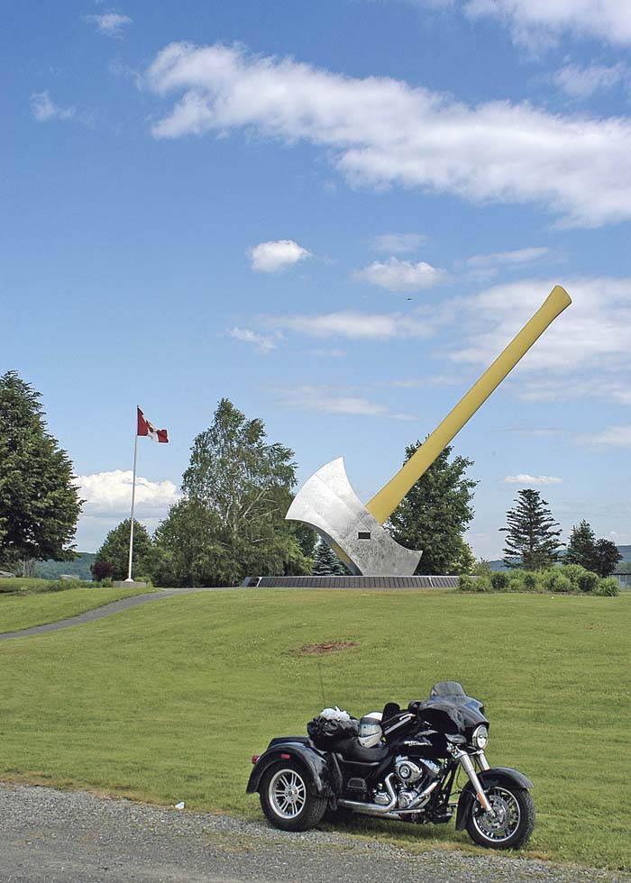
I ease into Nackawic on the old road. Fortunately I don’t have an axe to grind because at 66 feet long and with a stainless-steel head weighing 7 tons, this one is the largest in the world. It’s dedicated to the forest industry and—give them credit—there’s not one mention of Paul Bunyan.
This route continues to Fredericton, but I decide to hop over to Route 102 on the other bank. At this point one side is no better than the other, but I want the opportunity to cross atop the Mactaquac Dam, the largest power project in New Brunswick. On one side of the narrow road I’m eye to eye with recreational boaters on the reservoir; on the other is a 123-foot drop to the rocks far below.
Fredericton is British. It once was the main garrison and is now the capitol of the province. Official signs are bilingual, but street names are British. People speak English and public places have English names. I’m booked at the Crowne Plaza where both the general manager and the desk manager are motorcyclists. No worries about the Glide; they have me put it on the walkway by the entrance. There are reputedly great restaurants, cafes and bars in this historic downtown district. However, I’m asked by management to critique an experimental menu created by top chef Brent Conlin and don’t make it past the front doors.
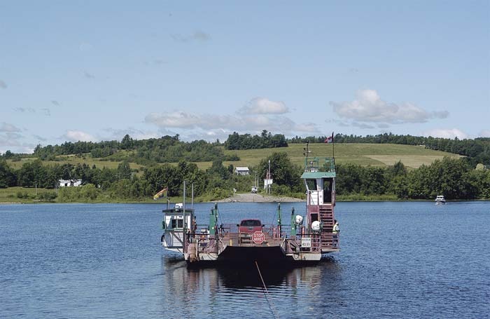
Yes, there’s a bit to see in Fredericton, including the famous 40-lb Carleton Frog, but the next morning finds me back on Route 105 and heading south along a river fractured by islands and laced by sandbars. Going local, I take the well-marked Route 695 and 715 through Lower Jemseng to cross the river on the Gageville Ferry.
These cable ferries on the lower Saint John, which are both free and numerous, are convenient, quick, and much more fun than a bridge. This is the most northern one. In a matter of minutes I’m headed south on Route 102 along the most extensive wetlands in all the Maritimes. Bald eagles, ospreys, blue herons, geese and ducks move between worlds of vivid green and blue. Once again, I’m essentially alone on the road. When I stop, the songs of countless birds dominate this bucolic landscape.
I wake up and there’s an ocean liner moored outside my door. It’s the Carnival Glory and taller than the 11-story Hilton. I’m in Saint John, the city at the mouth of the Saint John River, and it’s Canada Day, the equivalent to 4th of July in the U.S. Downtown is one giant yard sale, live music is playing, beer is the beverage of choice on restaurant patios, the fantastic New Brunswick Museum has thrown open its doors and I’m not getting on the trike today.
I’ve ridden down the Walloostook from the remote northern forests to the southern international port city. Along the way the river told me its own story, unfolding like ever-flowing water that transforms, and is transformed by, the land through which it travels. Within this valley I discovered the richest agricultural land in the province, and also the richest heritage. Tomorrow… “Excuse me; will you bring me another beer? Thank you.” …I’ll continue on to Saint Andrews-by-the-Sea where the Atlanticade rally is taking place. Meanwhile I’m just going to kick back and enjoy the show.